You used science? Careful - science is frowned upon 'round these 'ere parts.Believe it or not, warmer = more snow.
Air at 30 F holds more moisture than Air at 25 F, ie more precipitation in the winter. Obviously my response is oversimplified, but your generalization is wrong. Cue the "Constitution" or a "Big Government" argument.....
Sobering global warming article...
- Thread starter crimsonaudio
- Start date
That would have wiped out all the fishies.I think he washed Whoopie's dreads in all the seven seas.
FIFYYou used a red herring? Careful - logical fallacy is frowned upon 'round these 'ere parts.
A common misperception. I keep seeing this repeated over and over and rarely see a factual explanation or rebuttal. While it's true that warmer air holds more moisture in the form of water vapor, this is the very reason that warmer air produces less snowfall.Believe it or not, warmer = more snow.
Air at 30 F holds more moisture than Air at 25 F, ie more precipitation in the winter. Obviously my response is oversimplified, but your generalization is wrong. Cue the "Constitution" or a "Big Government" argument.....
Bear with me, because this gets a bit technical. Or just dismiss it off hand, whichever you prefer. :tongue:
The "temperature" is the measure of thermal energy in the air. The "dewpoint temperature" is the temperature at which the water vapor which is contained in the air will condense into a liquid, and thereby form cloud droplets or ice crystals (if cold enough). This dewpoint temperature is largely a function of the density of the water vapor in the air (referred to as "saturation vapor pressure") - high water vapor density (more water vapor/volume) = higher dewpoint temperature. Low water vapor density (less water vapor/volume) = lower dewpoint temperature. This state, where the temperature just lowers to the dewpoint temperature is referred to as "saturation", and produces clouds made of either suspended tiny water droplets or suspended ice crystals, but not yet any precipitation.
As the water vapor changes state from a gas to either a liquid or solid, two primary things occur. Firstly, the density of the water vapor is reduced, thereby slightly lowering the dewpoint temperature. Secondly, the change of state from gas to liquid and liquid to solid releases latent heat to the air, thereby slightly raising the temperature. Consequently, the temperature can NEVER be less than the dewpoint temperature. As the temperature continues to drop, so must the dewpoint temperature. So the total water content of a parcel of air is ALWAYS capped by the temperature of that parcel. And as more and more water vapor changes state to either liquid or solid, the droplets and/or ice crystals present become more and more numerous (the cloud becomes more dense).
Precipitation is what occurs when the temperature continues to lower past the dewpoint (referred to as "super-saturation"), adding increased condensed water droplets or ice crystals, which coalesce to form large enough and heavy enough particles to fall. In other words, Precipitation is the consequence of moisture being "squeezed" out of the atmosphere by a lowering temperature.
In an atmosphere with a temperature of 100F, the dewpoint temperature (again, proportional to water vapor content) can be up to and including 100F. If in this hypothetical scenario the dewpoint is 60F, you won't have any clouds until the temperature lowers to 60F, and no precipitation until the temperature lowers further. In a different scenario where both the atmospheric temperature and the dewpoint temperature are 20F, even though there's much less total moisture available than in the 100F scenario, clouds and perhaps precipitation will occur because the temperature has lowered to and perhaps beyond the natural dewpoint.
So in summary, though you're correct in saying that warm air = more moisture capacity (but not necessarily more moisture), warm air does not necessarily = more snow. Super-saturation = more snow. And super-saturation is more likely the colder the air becomes.
Of course, none of that discussion has any bearing whatsoever on whether or not more snowy conditions are indicative of either a warming climate or a cooling climate. The amount of snow seen in a specific region during a specific season is dependent on much, much more than simply temperature and dewpoint. Seasonal weather patterns, transient climate regimes, multi-year cycles like el-nino and la-nina, the state of the pacific decadal and atlantic multi-decadal oscillations, and many other factors can overwhelm any trend dictated by the principle illustrated above. The fact that there was more snowfall in the northeast US this past year bears no indication whatsoever of the impact or lack thereof of anthropogenic global warming.
But you don't understand, he used science. So he has that going for him.A common misperception. I keep seeing this repeated over and over and rarely see a factual explanation or rebuttal. While it's true that warmer air holds more moisture in the form of water vapor, this is the very reason that warmer air produces less snowfall.
Bear with me, because this gets a bit technical. Or just dismiss it off hand, whichever you prefer. :tongue:
The "temperature" is the measure of thermal energy in the air. The "dewpoint temperature" is the temperature at which the water vapor which is contained in the air will condense into a liquid, and thereby form cloud droplets or ice crystals (if cold enough). This dewpoint temperature is largely a function of the density of the water vapor in the air (referred to as "saturation vapor pressure") - high water vapor density (more water vapor/volume) = higher dewpoint temperature. Low water vapor density (less water vapor/volume) = lower dewpoint temperature. This state, where the temperature just lowers to the dewpoint temperature is referred to as "saturation", and produces clouds made of either suspended tiny water droplets or suspended ice crystals, but not yet any precipitation.
As the water vapor changes state from a gas to either a liquid or solid, two primary things occur. Firstly, the density of the water vapor is reduced, thereby slightly lowering the dewpoint temperature. Secondly, the change of state from gas to liquid and liquid to solid releases latent heat to the air, thereby slightly raising the temperature. Consequently, the temperature can NEVER be less than the dewpoint temperature. As the temperature continues to drop, so must the dewpoint temperature. So the total water content of a parcel of air is ALWAYS capped by the temperature of that parcel. And as more and more water vapor changes state to either liquid or solid, the droplets and/or ice crystals present become more and more numerous (the cloud becomes more dense).
Precipitation is what occurs when the temperature continues to lower past the dewpoint (referred to as "super-saturation"), adding increased condensed water droplets or ice crystals, which coalesce to form large enough and heavy enough particles to fall. In other words, Precipitation is the consequence of moisture being "squeezed" out of the atmosphere by a lowering temperature.
In an atmosphere with a temperature of 100F, the dewpoint temperature (again, proportional to water vapor content) can be up to and including 100F. If in this hypothetical scenario the dewpoint is 60F, you won't have any clouds until the temperature lowers to 60F, and no precipitation until the temperature lowers further. In a different scenario where both the atmospheric temperature and the dewpoint temperature are 20F, even though there's much less total moisture available than in the 100F scenario, clouds and perhaps precipitation will occur because the temperature has lowered to and perhaps beyond the natural dewpoint.
So in summary, though you're correct in saying that warm air = more moisture capacity (but not necessarily more moisture), warm air does not necessarily = more snow. Super-saturation = more snow. And super-saturation is more likely the colder the air becomes.
Of course, none of that discussion has any bearing whatsoever on whether or not more snowy conditions are indicative of either a warming climate or a cooling climate. The amount of snow seen in a specific region during a specific season is dependent on much, much more than simply temperature and dewpoint. Seasonal weather patterns, transient climate regimes, multi-year cycles like el-nino and la-nina, the state of the pacific decadal and atlantic multi-decadal oscillations, and many other factors can overwhelm any trend dictated by the principle illustrated above. The fact that there was more snowfall in the northeast US this past year bears no indication whatsoever of the impact or lack thereof of anthropogenic global warming.
")
Nice job PT. Of course it won't convince those who's minds are made up. :smile: Unless of you wrote this for the NY Times or even Huffington Post as then it truly becomes scientific.
I do remember in the '70's when the next world ending event was another ice age. :eek2:
I do remember in the '70's when the next world ending event was another ice age. :eek2:
Last edited:
LOL.... So we fixed the ozone layer? Is it because my Grandma quit using VO5 and Aqua Net?Thats a poor example for a denier to use. Science spoke, government listened and today its not the growing threat it once was.
negative V05 and Aqua Net were not to blame ....LOL.... So we fixed the ozone layer? Is it because my Grandma quit using VO5 and Aqua Net?

Thats a very simplistic (aka snarky) way to look at it but yes, we are making progress.LOL.... So we fixed the ozone layer? Is it because my Grandma quit using VO5 and Aqua Net?
Now there's a thought. You and your GW buddies could back out of all your bs hysterical claims of global catastrophe by turning around and saying that we've now fixed the problem.Thats a very simplistic (aka snarky) way to look at it but yes, we are making progress.
Now that might work. :wink:
Thanks for the actual response! I know that all your buddies have already assumed you were right, and you are in several spots, but you didn't disprove my response, but simply state that what I said is not ALWAYS correct. Like I said, I oversimplified and perhaps what I should have said was, in a warmer climate, when it does snow, it has the capability to produce more snow due to a higher capacity. Frequency and amount are different things as 2 snow storms at 12 inches each will still be more snowfall than 5 snow storms at 2 inches each.A common misperception. I keep seeing this repeated over and over and rarely see a factual explanation or rebuttal. While it's true that warmer air holds more moisture in the form of water vapor, this is the very reason that warmer air produces less snowfall.
Of course, none of that discussion has any bearing whatsoever on whether or not more snowy conditions are indicative of either a warming climate or a cooling climate. The amount of snow seen in a specific region during a specific season is dependent on much, much more than simply temperature and dewpoint. Seasonal weather patterns, transient climate regimes, multi-year cycles like el-nino and la-nina, the state of the pacific decadal and atlantic multi-decadal oscillations, and many other factors can overwhelm any trend dictated by the principle illustrated above. The fact that there was more snowfall in the northeast US this past year bears no indication whatsoever of the impact or lack thereof of anthropogenic global warming.
And I 100% agree that any short-term climate variations has nothing to do with anthropogenic global warming.
Last edited:
And I 100% agree that any short-term climate variations has nothing to do with anthropogenic global warming.
I guess the question always comes back to: What is the definition of "short-term variation" with respect to global climate?
Hello Tidefans non-sports junkies! Bet you thought I gave up and just withered away under all your scorn and right wing rhetoric. Uh uh. Still around. Became a dedicated Christian. Married again after losing my wife of 44 years. But still a moderate, still believe that there is science. Still opposed to posts that essentially encourage us not to think.
Global Warming is here. We are experiencing it across our country. I just drove from Alabama to Lake Superior in Wisconsin, and the corn in Illinois and southern Wisconsin is brown at the base and two feet shorter than it should be. The data is as clear as the visible evidence.
So the response here is to declare that we are in a natural cycle; or that people have been wrong before; or that there is a conspiracy to increase our taxes; or to shoot the messenger; or that we have snow in the winter so it can't be getting warmer: or that we can't do anything about it anyway so just shut up. The last may be the most operative response. Just lean down and force your head between your knees and kiss your *** goodbye.
I don't know if we can do anyuthing as humans to reverse it, but I do agree that energy companies get an amazing free ride. The dump their waste into the atmosphere, and it increases their profit margin at our expense. You can't do that to the rivers or the oceans without a penalty. Instead we give them an oil depletion allowance, a tax break because oil is a non-renewable resource! I say tax them, and give them an incentive to produce cleaner energy. That will drive up the price of fossil fuels, making it more feasible to produce more efficient automobiles and light bulbs. It also might possibly save out planet from a drastic future...
I don't know who you are, but Lilred likes you.Hello Tidefans non-sports junkies! Bet you thought I gave up and just withered away under all your scorn and right wing rhetoric. Uh uh. Still around. Became a dedicated Christian. Married again after losing my wife of 44 years. But still a moderate, still believe that there is science. Still opposed to posts that essentially encourage us not to think.
I'm afraid this right wing rhetoric battle station is quite operational.
Last edited:
That's quite the formidable straw man army you've built there.So the response here is to declare that we are in a natural cycle; or that people have been wrong before; or that there is a conspiracy to increase our taxes; or to shoot the messenger; or that we have snow in the winter so it can't be getting warmer: or that we can't do anything about it anyway so just shut up. The last may be the most operative response. Just lean down and force your head between your knees and kiss your *** goodbye.
I earlier pointed out that I recently experienced one of the longest, coldest winters in recorded history for my area of the country. Timing the global warming hysteria is everything, I guess.
And, let's bottom line this thing. What is the government solution? Corn ethanol? Solyndra? Expensive European-style non-solutions? Lining Al Gore's pockets? Bird-killing windmills?
Or maybe there really isn't a government solution because government is only good at wasting money and delaying real market-driven innovation.
And I don't think anyone here is anti-science. Many are rightly suspicious of government "solutions."
Last edited:
So are you saying to think about it or do something about it? I'm honestly confused. It seems like you are declaring it an emergency for which we need to act while deriding those who say it's not and accusing them/us of not thinking even as you seem to say there's no need to stop and think about it? Help me out here, bobstod.Hello Tidefans non-sports junkies! Bet you thought I gave up and just withered away under all your scorn and right wing rhetoric. Uh uh. Still around. Became a dedicated Christian. Married again after losing my wife of 44 years. But still a moderate, still believe that there is science. Still opposed to posts that essentially encourage us not to think.
Global Warming is here. We are experiencing it across our country. I just drove from Alabama to Lake Superior in Wisconsin, and the corn in Illinois and southern Wisconsin is brown at the base and two feet shorter than it should be. The data is as clear as the visible evidence.
So the response here is to declare that we are in a natural cycle; or that people have been wrong before; or that there is a conspiracy to increase our taxes; or to shoot the messenger; or that we have snow in the winter so it can't be getting warmer: or that we can't do anything about it anyway so just shut up. The last may be the most operative response. Just lean down and force your head between your knees and kiss your *** goodbye.
I don't know if we can do anyuthing as humans to reverse it, but I do agree that energy companies get an amazing free ride. The dump their waste into the atmosphere, and it increases their profit margin at our expense. You can't do that to the rivers or the oceans without a penalty. Instead we give them an oil depletion allowance, a tax break because oil is a non-renewable resource! I say tax them, and give them an incentive to produce cleaner energy. That will drive up the price of fossil fuels, making it more feasible to produce more efficient automobiles and light bulbs. It also might possibly save out planet from a drastic future...
Say we start taxing the crap out of all the oil and gas companies. Well then the price of doing everything will go up. Literally everything. If you think the economy is bad now, you haven't seen anything. Commerce in this country will grind to a halt. People will not be able to drive to work, their power bills will be astronomical.Hello Tidefans non-sports junkies! Bet you thought I gave up and just withered away under all your scorn and right wing rhetoric. Uh uh. Still around. Became a dedicated Christian. Married again after losing my wife of 44 years. But still a moderate, still believe that there is science. Still opposed to posts that essentially encourage us not to think.
Global Warming is here. We are experiencing it across our country. I just drove from Alabama to Lake Superior in Wisconsin, and the corn in Illinois and southern Wisconsin is brown at the base and two feet shorter than it should be. The data is as clear as the visible evidence.
So the response here is to declare that we are in a natural cycle; or that people have been wrong before; or that there is a conspiracy to increase our taxes; or to shoot the messenger; or that we have snow in the winter so it can't be getting warmer: or that we can't do anything about it anyway so just shut up. The last may be the most operative response. Just lean down and force your head between your knees and kiss your *** goodbye.
I don't know if we can do anyuthing as humans to reverse it, but I do agree that energy companies get an amazing free ride. The dump their waste into the atmosphere, and it increases their profit margin at our expense. You can't do that to the rivers or the oceans without a penalty. Instead we give them an oil depletion allowance, a tax break because oil is a non-renewable resource! I say tax them, and give them an incentive to produce cleaner energy. That will drive up the price of fossil fuels, making it more feasible to produce more efficient automobiles and light bulbs. It also might possibly save out planet from a drastic future...
I'm sorry, but I don't want to go through all of this simply because YOU think the oil companies make too much money. What business is it of yours how much money they make anyway? They employ thousands and provide great benefits to those employees.
In a single snow event, all other things being equal save temperature, in one case being 30F and in another case being 20F, because the 30F atmosphere has the capability to contain more precipitable water (untapped water vapor) than the 20F atmosphere, yes, it has the capability to produce more snow.Thanks for the actual response! I know that all your buddies have already assumed you were right, and you are in several spots, but you didn't disprove my response, but simply state that what I said is not ALWAYS correct. Like I said, I oversimplified and perhaps what I should have said was, in a warmer climate, when it does snow, it has the capability to produce more snow due to a higher capacity. Frequency and amount are different things as 2 snow storms at 12 inches each will still be more snowfall than 5 snow storms at 2 inches each.
And I 100% agree that any short-term climate variations has nothing to do with anthropogenic global warming.
But just as there are two aspects to a high seasonal total (frequency and amount), there are also two primary requirements to a high single event total (moisture and temperature). 1. Precipitable water must be high. 2. The temperature must be low enough to induce super-saturation. Those two variables are in direct conflict with each other, for even though you want to maximize moisture, requiring a higher temperature, you need a temperature which is low enough to induce super-saturation, and also low enough for the resultant precipitation to be in the form of snow.
How low that super-saturation threshold is is very much dependent on the amount of precipitable water, which is capped by, though not dictated by, the temperature. The super-saturation threshold is dictated by the dewpoint, an indication of the the actual (not capable) amount of moisture present. That is to say, simply because the temperature is higher, does not mean the moisture is higher. It just means that moisture can be higher. They are two independent variables. Focusing on maximizing the capability for precipitable water by way of raising the temperature is ignoring half of the requirements, nay - contradicting it, for the sake of a capability, as opposed to an actuality.
Think of it like this: the temperature is an empty bathtub. Low temperature = small bathtub. High temperature = big bathtub. The size of the bathtub determines how much water it can hold. But it does not determine how much water is placed in it. How much water is placed in it is determined by the flow rate of the faucet, independent of the size of the tub. You can put much more water in a big tub than you can in a small tub before the water starts spilling over the sides (precipitation). And how much spillage you get is not determined by the size of the tub either. The overflow is determined by the size of the tub relative to the faucet's flow rate.
Little tub (low temperature) + high flow rate (high moisture) = big mess
Big tub (high temperature) + low flow rate (low moisture) = dry bathroom
What you're proposing is...
Big tub (high temperature) = high flow rate (high moisture) = big mess
...completely ignoring the independence of the variables and the necessity of looking at each relative to the other.
But again, that's all in regard to a single event. When we speak of climate change, we're not speaking of a single event. We're speaking of climate. Climate is defined as the composite or generally prevailing weather conditions of a region, as temperature, air pressure, humidity, precipitation, sunshine, cloudiness and winds, through the year, averaged over a series of years. So you're wise in approaching it from a frequency-and-amount perspective. In a warmer environment, there exists the potential for more moisture and therefore perhaps more snow in an individual snow event. There will be fewer events.
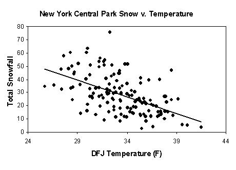
But your arbitrary assumption of 2 events at 12 inches each vs 5 events at 2 inches each is just that: arbitrary. And there's no need to be arbitrary when we have the empirical data to be precise. The graphic I provided tells the complete story.
Each point represents a single winter season's average temperature vs a single season's total snowfall for New York's Central Park. I haven't counted each data point but I'll estimate that what we're looking at here is about 100-150 years worth of data. What it clearly shows is a definite trend that in general, the colder a particular winter was, the more snow that fell. This trend is not specific to New York. Take for instance, Philadelphia:

Same trend. Same approximate slope. In some cases, the relationship is more correlated and in others less. But all over the world, it's the same trend: colder winter = more snow; warmer winter = less snow. This is not arbitrary. This is not subjective. This is cold hard empirical facts.
So you're right: I didn't disprove your response with my discussion of single-event physical processes. But when we're talking about climate trends and whether or not a warmer climate produces more snow, the empirical evidence does disprove your response. A warmer climate produces less seasonal snow.
Hi, Bob. Welcome back.Hello Tidefans non-sports junkies! Bet you thought I gave up and just withered away under all your scorn and right wing rhetoric. Uh uh. Still around. Became a dedicated Christian. Married again after losing my wife of 44 years. But still a moderate, still believe that there is science. Still opposed to posts that essentially encourage us not to think.
Condolences on the loss of your first wife and congrats on your second marriage. I'm happy for your.
This. Welcome back, Bob!Hi, Bob. Welcome back.
Condolences on the loss of your first wife and congrats on your second marriage. I'm happy for your.
p.s. - seems you jumped off the high dive into the deep end of the pool; no easy non-controversial re-entry for you, huh? :biggrin2:
TideFans.shop - 25% off Fan Favorites!
TideFans.shop - 25% off!

Get this and many more items at our TideFans.shop!
Purchases may result in a commission being paid to TideFans.Latest threads
-

-
Question: Tax experts and/or lawyers; How much from a settlement should I set aside for taxes?
- Started by CrimsonNagus
- Replies: 9
-

-
-
-