Weather thread, Part III
- Thread starter crimsonaudio
- Start date


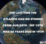

Yeah......the latest TS, Gabrielle, looks like another nothing-burger......
Let's hope that what happened two days later in 1939 doesn't repeat itself.
Hint: An invasion of Poland.
Let's steer this conversation back to something else...Let's hope that what happened two days later in 1939 doesn't repeat itself.
Hint: An invasion of Poland.
So, how 'bout them Braves???

I only paid attention to the Braves yesterday. Man, they are horrible.Let's steer this conversation back to something else...
So, how 'bout them Braves???
This from a former long-time fan. I kind of lost track of them over the years. I was in Fulton Co. Stadium the day Greg Maddux threw a one-hitter...a week before the big strike in 1994. Even though they won the Series the next year, I lost interest in them after the strike.
they don't suck, they still have not been eliminated from the playoff picture. I believe they would need to win out and have every team just ahead of them lose out. 9 games left and 8.5 games out of it.I only paid attention to the Braves yesterday. Man, they are horrible.
This from a former long-time fan. I kind of lost track of them over the years. I was in Fulton Co. Stadium the day Greg Maddux threw a one-hitter...a week before the big strike in 1994. Even though they won the Series the next year, I lost interest in them after the strike.
Today is the first day of Autumn!
Also known as the Autumnal Equinox.
Starting tomorrow the nights will become longer than the days.
HAPPY FALL, my friends!")
Also known as the Autumnal Equinox.
Starting tomorrow the nights will become longer than the days.
HAPPY FALL, my friends!
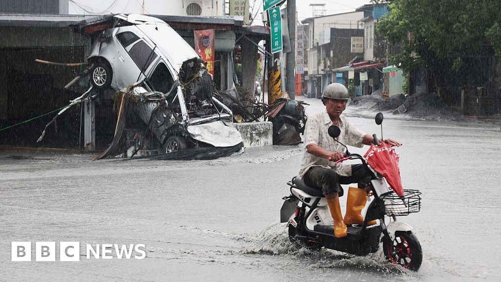
Typhoon Ragasa makes landfall in China after 17 killed in Taiwan
Ragasa is the world's strongest storm this year and has been roaring over the South China Sea for days.

Jeff Berardelli (Meteorologist):
Fujiwhara?? When two hurricanes interact, they can sometimes pivot around one another. Next week there will likely be 2 tropical cyclones (perhaps 2 hurricanes) offshore. If they are strong enough, and are close enough, a #Fujiwhara may happen. Here’s how it works. Between the 2 storms is a pivot point (sort of like a fulcrum on a seesaw), it happens to be near where the sinking/ driest air is. If conditions are right we may see them pivot, or if one’s stronger (Bermuda hurricane) its force will sling shot the weaker one around it. Still not clear to what degree the Fujiwhara effect will be in effect, but it ought to be interesting!

Hurricane forecasters watch for rare, chaotic Fujiwhara effect
The dance between developing storms in the Atlantic could soon evolve into one of meteorology's most unusual and rare events: The Fujiwhara effect.
www.usatoday.com
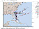
Latest - looks like FL is safe but SC appears to be in the crosshairs…
Or the one through Huntsville...i don’t like the paths going towards wnc
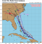
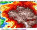
FRIDAY AFTERNOON TROPICAL UPDATE:
Invest 94L will likely become Imelda so in this post I will refer to it as future Imelda. This system has not formed yet so models do not have the best handle on the future. That being said, at this point it looks more likely than not that the Carolinas will see a direct impact. Below are a couple models showing future rain totals.
SCENARIOS:
1. The greatest possibility at this time will be direct impacts to the Carolinas.
2. Another possibility, which is still not off the table, is Hurricane Humberto has influence on future Imelda and slingshots it out to sea. This scenario is less likely at this time.
If scenario 1 plays out, here are my early thoughts:
TIMING: Monday - Wednesday
RAINFALL: This is will be biggest threat, especially if the system stalls out. There could a corridor that picks up 12+’’. For the WCCB Charlotte area, right now most models are showing 3-6’’+ from now until midweek next week. Where the heaviest rain sets up will depend on the final track. Also note, we are seeing days of scattered showers before any tropical moisture makes it to the area. The stalled front and future Imelda could mean ***significant flooding for some.***
WIND: This too depends on the track. Most guidance shows this system at Tropical Storm or low end hurricane strength. The strongest winds will be north / northeast of the center.
STORM SURGE: Like any landfalling tropical system, storm surge is a threat. Due to the shape of the coast, those along and north of the center will have the greatest surge impact.
BOTTOMLINE: This is not a slam dunk forecast yet, but please be prepared.
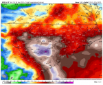
Predicted Wed, Oct 1 rainfall:
Predicted Thursday, Oct 2 rainfall:
Predicted Friday, October 3 rainfall:
Invest 94L will likely become Imelda so in this post I will refer to it as future Imelda. This system has not formed yet so models do not have the best handle on the future. That being said, at this point it looks more likely than not that the Carolinas will see a direct impact. Below are a couple models showing future rain totals.
SCENARIOS:
1. The greatest possibility at this time will be direct impacts to the Carolinas.
2. Another possibility, which is still not off the table, is Hurricane Humberto has influence on future Imelda and slingshots it out to sea. This scenario is less likely at this time.
If scenario 1 plays out, here are my early thoughts:
TIMING: Monday - Wednesday
RAINFALL: This is will be biggest threat, especially if the system stalls out. There could a corridor that picks up 12+’’. For the WCCB Charlotte area, right now most models are showing 3-6’’+ from now until midweek next week. Where the heaviest rain sets up will depend on the final track. Also note, we are seeing days of scattered showers before any tropical moisture makes it to the area. The stalled front and future Imelda could mean ***significant flooding for some.***
WIND: This too depends on the track. Most guidance shows this system at Tropical Storm or low end hurricane strength. The strongest winds will be north / northeast of the center.
STORM SURGE: Like any landfalling tropical system, storm surge is a threat. Due to the shape of the coast, those along and north of the center will have the greatest surge impact.
BOTTOMLINE: This is not a slam dunk forecast yet, but please be prepared.
Predicted Wed, Oct 1 rainfall:
Predicted Thursday, Oct 2 rainfall:
Predicted Friday, October 3 rainfall:
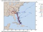
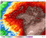
Important Saturday Tropical Update:
1.A Cat 5 and a blob are about to make things very tricky. Humberto expected to become a Cat 5 by Sunday while PTC is forecast to become a hurricane in a few days. Now what?
2. 1st of all, Humberto won't impact the US whatsoever, but it likely WILL impact Imelda (to be). Looks like the 2 storms will interact to cause Imelda to stall out somewhere near the SC/GA coast. Even if landfall never occurs, flooding rains are likely along the coast and potentially in the mountains. However, the strongest winds WILL REMAIN OFFSHORE.
3. We still have no defined center and until we do, forecasting exact details is impossible. But as you see below, there is a ton of model agreement in spite of the murky details.
4. No impacts to the Bay Area however, the East coast will see heavy surf.
5. Driving will likely be tricky starting later Monday through Wednesday for the SE coast. Flights could be impacted as well, but I think the worst stays offshore so I wouldn't expect huge issues.
6. Cruises will see rough conditions. Some cruise lines might change itineraries to avoid the storms.
7. "Skelly Watch": The Caribbean and Gulf are still looking good right into the 2nd week of October. So far, so good for your Halloween decorations in the Bay Area. Fingers crossed we avoid "Tropical Troubles" this year. After last season, we've earned a break.
8. I'll have a video later this morning after model and NHC updates. Rule #7.
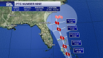
This is a positive update!
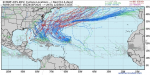
Saturday 11am NHC update on now Tropical Depression #9. The curve is looking more and more likely. Cone has shrunk. Outer bands still might reach some along the coast. Florida east coast with Tropical Storm Watches. spaghettimodels.com

Saturday 11am NHC update on now Tropical Depression #9. The curve is looking more and more likely. Cone has shrunk. Outer bands still might reach some along the coast. Florida east coast with Tropical Storm Watches. spaghettimodels.com
I love it over the earlier ones showing it heading due west, straight inland...This is a positive update!
Saturday 11am NHC update on now Tropical Depression #9. The curve is looking more and more likely. Cone has shrunk. Outer bands still might reach some along the coast. Florida east coast with Tropical Storm Watches. spaghettimodels.com
View attachment 53231
TideFans.shop - Get your Gear HERE!
Alabama Crimson Tide Car Door Light
Get this and many more items at our TideFans.shop!
Purchases may result in a commission being paid to TideFans.