Weather thread, Part III

  • HELLO AGAIN, Guest! We are back, live! We're still doing some troubleshooting and maintenance to fix a few remaining issues but everything looks stable now (except front page which we're working on over next day or two)

    Thanks for your patience and support! MUCH appreciated! --Brett (BamaNation)

    if you see any problems - please post them in the Troubleshooting board!

Nothing special yet with the surf here. Little bit of rain bands sifting through. Not much of a breeze yet either. Guess it picks up more tomorrow..... 🤷‍♂️

IMG_3267.JPG
 
  • Like
Reactions: crimsonaudio
Mother Nature....she always has the last word! And this is why people hate insurance companies so much.....

My best friend, now unfortunately deceased, got out of Buxton just in time. He'd already raised their house around 15' and they lived on the back, bay side. He practically had to pry his wife out of there with a crowbar. Her ancestors settled that part of the island and her grandfather's name was on one of the old foundation stones at the original lighthouse location...
 
I would be surprised if these homes were even covered for this type event. Most property policies have a subsidence exclusion in them. Its a caveat in insurance.
Mother Nature....she always has the last word! And this is why people hate insurance companies so much.....

 
I would be surprised if these homes were even covered for this type event. Most property policies have a subsidence exclusion in them. Its a caveat in insurance.
When my friend lived there, around ten years ago now, standard insurance wasn't available. They had "risk pool" coverage, something like that, which, I think, was state-sponsored. Even back then, it was several thousand dollars annually...
 

Meteorologist Dylan Federico

I’m gravely concerned for Jamaica. Melissa has the potential to become to the worst hurricane to strike Jamaica since Gilbert in 1988. We are talking about a slow-moving major hurricane passing near if not directly over the island this weekend into early next week — potentially as a Category 4 or 5. Everyone in Jamaica should be preparing for a major hurricane strike with a long duration of hurricane conditions lasting 2-3+ days Saturday/Sunday into Monday/Tuesday next week. All preparations to protect life and property should be completed by this weekend. Multiple days of non-perishable food, water, and medicine will be needed. Check with local officials for evacuation orders. Catastrophic flooding & mudslides from multiple feet of rain are my biggest concern. Storm surge is another threat depending on the exact track. You can hide from the wind, but you can’t from the water. With this being a major hurricane, wind will cause significant damage to infrastructure and even the strongest of buildings. Please take this storm seriously if you live in Jamaica. The best thing you can do is prepare now!

1761271644024.png
 
Melissa has the potential to be the worst hurricane to ever impact Jamaica, and by a very large margin. A disaster centered around extreme flooding and landslides is possible. New hurricane models tonight shown below indicate a max intensity Category 4 or 5, with a "pinhole" eye Monday next week. The storm will likely sit, stop, or loop off the Jamaican coast before inching NE towards the island sometime next Tuesday (Oct. 28) as a possibly catastrophic hurricane. The exact location of its turn to the NE, and therefore potential landfall, are still unknowns. Some models landfall it directly in Kingston (absolute worst case scenario) -- others on the far western side of the island.
Preparations should be rushed to completion. If you had plans to travel to Jamaica next week, they are likely going to be canceled or impacted in its wake. If you are visiting Jamaica and contemplating staying, I cannot stress in any stronger terms you should leave if it all possible.
If there is something to "hope" for - is that the eye of the storm somehow stays just east of the island which would still be major, but far less devastating and extreme. Overall models range from a landfall in western Jamaica, eastern Jamaica, or tracking just off the eastern tip of the island.
‣ Storm surge on the southern coastline could be major.
‣ Tornadoes are likely in the outer bands, even in the mountains.
‣ Massive rain totals are likely if this track comes to be correct.
Aided by mountain enhancement... rain totals in many areas could easily pass 25" with potential for pockets of 40"+ of rain. Placement of extreme rain, wind, and surge will be dictated by the storms final track. But a major hurricane moving this slowly in the Caribbean is extremely rare, let along impacting a landmass while doing so.
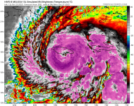
Satellite image below (left) is Monday afternoon.
Simulated radar image (Right) is early Tuesday morning.
-
Meteorologist Noah Bergren, Fox35 Orlando

1761356084755.png
1761356100268.png
 
A dropsonde released by the Hurricane Hunters at 8:55 a.m. EDT recorded an astonishing wind gust of 241 mph (388 km/h) at an altitude of 709 feet, one of the highest wind gusts ever measured in a hurricane. An Air Force hurricane hunter reported birds were trapped in the eye, and NOAA hurricane hunter aircraft N42RF (Kermit) was forced to abort their flight after two eye penetrations into Melissa on Monday morning, after encountering extreme turbulence in the southwestern eyewall. This is only the fifth time I’m aware of that the NOAA Hurricane Hunters have had to abort a flight because of extreme turbulence (the others: Allen in 1980, Emily in 1987, Hugo in 1989, and Felix in 2007).

Jamaica braces for Cat 5 Hurricane Melissa, Earth’s strongest storm of 2025

And the longer it sits offshore, the more strength it will gather. This is terrible!
 
  • Emphasis!
Reactions: crimsonaudio

New Posts

Advertisement

Trending content

Advertisement